


The Question Every Land Deal Comes Down To
You can spend days analyzing a parcel. Environmental constraints. Zoning designations. Ownership history. Competitive context. But at the end of that analysis, the decision always comes down to one number: how many lots fit on this land?
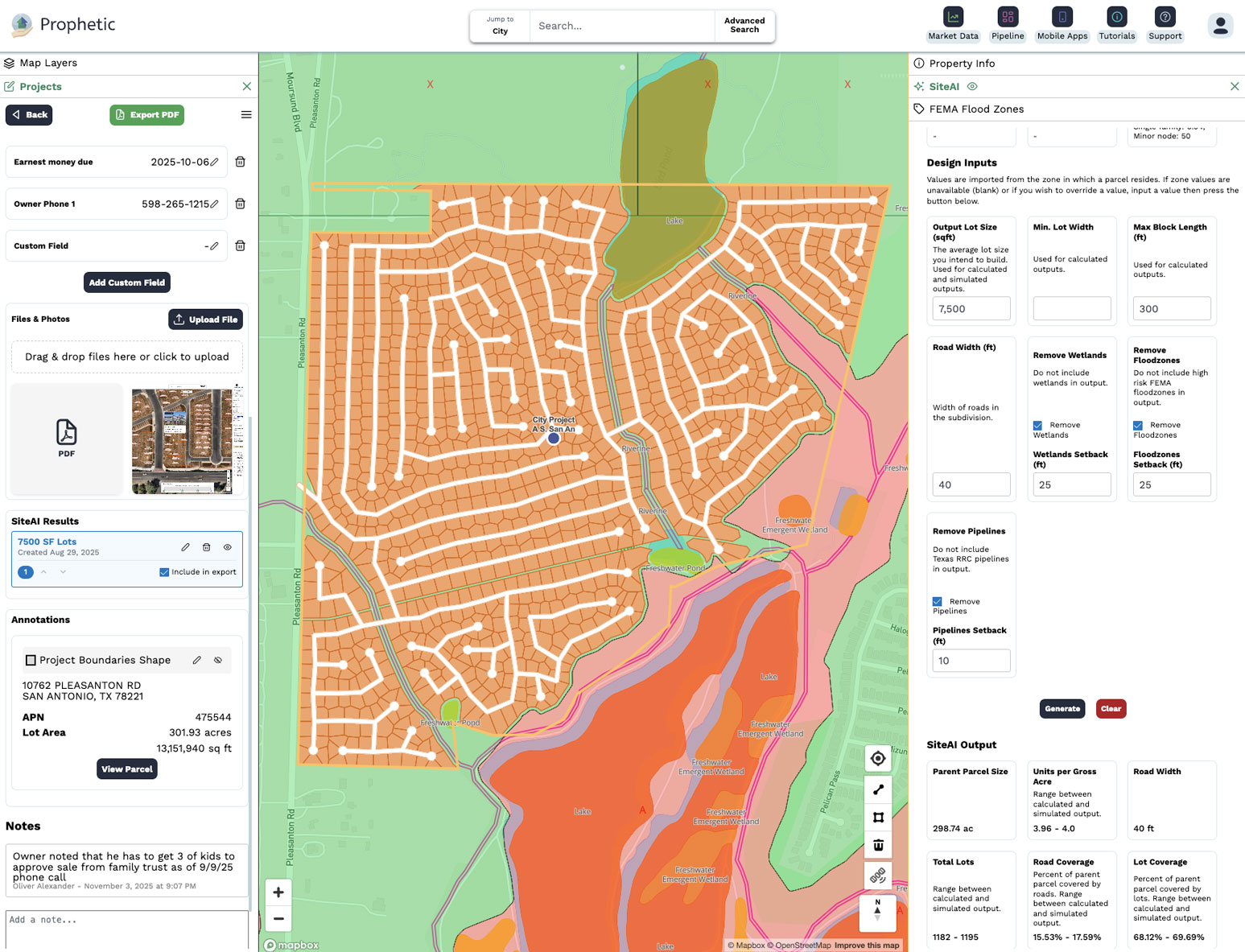
That number is what a yield study produces. It is not a guess or a rule of thumb. It is a calculated estimate of buildable units based on the specific combination of parcel geometry, zoning rules, environmental constraints, and physical characteristics that apply to that site.
If the yield is at or above your minimum threshold, the deal might work. If it is not, it does not matter how good everything else looks.
What a Yield Study Actually Calculates
A proper yield study accounts for more variables than most people outside the industry expect. The gross acreage of the parcel is only the starting point. The net buildable area, after subtracting the following, is what determines lot count.
Setback requirements from property lines, roads, and easements remove buildable area around the perimeter. Wetlands, floodplains, and other environmental constraint areas remove land entirely from development. Stormwater detention requirements, typically calculated as a percentage of impervious surface, consume land for retention ponds or bioswales. Open space minimums required by municipal code dedicate a percentage of the site to non-buildable park or trail land. Road rights-of-way and internal street infrastructure consume land proportional to the number of lots and the street layout design. And finally, your specific home model footprints, including the home itself, garage, and required side-yard setbacks, determine how many lots can be laid out in the remaining net buildable area.
A yield study that skips any of these variables is not a yield study. It is an optimistic projection that will be corrected later, usually at significant cost.
Why Traditional Yield Studies Take So Long
The traditional process requires a licensed civil engineer to produce a bubble study or preliminary site plan that accounts for all of the above variables. The engineer needs the parcel geometry, the applicable zoning code, the environmental constraint data, and your home model specifications. They then spend several days producing a site layout that shows how many lots fit.
The timeline depends on firm availability and workload. Two to three weeks is typical. The cost runs $5,000 to $10,000 per study for a site of modest complexity. For a pipeline of 50 candidate parcels, that math makes traditional yield studies impractical as a screening tool.
The result is that most teams do not run yield studies at the screening stage. They run them later, after the parcel has already made it deep into the evaluation process. By then, they have invested significant time and labor cost analyzing, and discovering that the yield does not work is expensive in both money and missed opportunity.
What AI-Powered Yield Studies Change
SiteAI generates yield studies by combining parcel geometry with zoning setback requirements, environmental constraint boundaries, stormwater calculations, road layout logic, open space minimums, and home model footprint specifications. The output is a density estimate accurate within 10% of what a full engineering study would produce.
For pipeline screening, 10% accuracy is more than sufficient. A parcel that produces 38 estimated lots when the minimum threshold is 40 should be flagged for further review. A parcel that produces 55 estimated lots is clearly above threshold. Those calls do not require engineering-grade precision.
What they do require is that the analysis happens at the right stage of the process. SiteAI makes that possible by removing the time and cost barriers that prevent early-stage yield analysis.
The Deal-Killer Detection Benefit
Beyond screening efficiency, AI-powered yield studies surface constraint situations that manual review misses. An irrigation district canal running beneath several parcels in central Oregon would not be obvious from a standard parcel map. A yield study that accounts for underground utility easements and required setbacks from infrastructure will flag that constraint automatically.
Keith Caylor at Pahlisch Homes experienced exactly this scenario. SiteAI recommended 40 lots on a parcel his team had projected at 50, a 20% difference attributable to infrastructure constraints that only appeared in a systematic yield analysis. The difference between 50 lots and 40 lots on a community of that scale was the difference between a profitable deal and likely a loss.
Early detection is not just efficiency. It is risk management.
What Customers Say
- "Site AI caught the irrigation canal under three parcels in Bend that would have cost us 10 lots, 20% of my initial estimate, plus development costs to enclose and backfill it. For that community size, it would have likely turned into a loss for the company." — Keith Caylor, Land Acquisition Manager, Pahlisch Homes
- "We were able to analyze a $3M deal, estimate 30 lots, and move into feasibility within hours. Prophetic made that possible." — VP Development, Regional Developer
- "The development feasibility report saves us so much time. When we have got five prospects and we want to make a quick decision about which ones we are going after, it cuts our decision-making time down by weeks." — General Manager of Land, Top 5 National Homebuilder
The Verdict
A yield study is not a late-stage formality. It is the most important early-stage filter in your pipeline. The teams that run it at the screening stage catch bad deals before they consume resources. The teams that run it late discover problems after the damage is done.
AI has removed the two reasons teams skip early-stage yield analysis: time and cost. There is no longer a good reason to wait.
See SiteAI generate a yield study on a real parcel. Book a demo.

